
Chapter 1 - Introduction
A Unique Place and Time
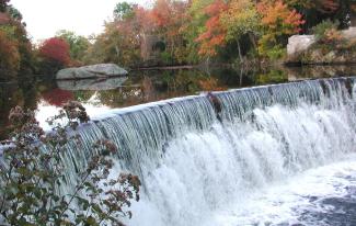
The landscape of South County is unlike any other in the Northeast, if not the whole country. Thousands of years of glaciation, erosion, and gradual development of plant and animal communities, followed by centuries of human use and modification, have created a unique landscape, where geology, history, nature and culture enrich and enliven each other. Each of these elements creates a kind of order in the landscape that ties the whole together, and they interact in a hundred ways. The result is a landscape that is rich in both natural resources and physical beauty, with constant variation within the unifying structure of a few continuous themes. One of these themes, for example, concerns the movement of water across the landscape. Draining the long narrow upland valleys in the Northwestern towns of the county, the tributaries of the Pawcatuck River descend gradually to the sea. Backed up behind the hills left by the glacier's terminal moraine at the end of the last ice age, these streams are forced west, through a series of ponds and wetland systems, all the way to Westerly and the Little Narragansett Bay. This diverse landscape and the many native plant and animal species that depend on it would be special enough; adding immeasurably to the complexity and vitality of the scene is a different theme, one flowing from human use of the rivers, forests, and rich agricultural soils of the region over centuries of intensive settlement. Mill villages sprang up wherever water could be harnessed to turn a wheel; agricultural settlements and outlying farmsteads dot the uplands; harbor towns grew up to store and ship the crops and goods produced in the interior, and gather in the harvest of the sea. These two patterns, the one natural and the other human, or cultural _ overlay each other and interact in a way that is both a visual historical record and an ongoing source of livelihood for South County's residents. The result is an extraordinarily beautiful landscape, a wonderful place to live, work, and recreate.
Of course, all this is threatened directly by the trends and forces that drive development in the modern age. In contrast to the historic development process, where homes and businesses, villages and towns grew up organically in balance with development of natural resources, agriculture and manufacturing, modern development is a market-driven process where land is bought wholesale, subdivided and sold at retail, often with little relationship to the underlying land. Planning and zoning are supposed to provide this connection, locating development where it is best suited and at appropriate densities. However, most communities have very rigid land use regulations that actually encourage or require developers to destroy the unique character defining features of the land without preserving any meaningful open space. These same inflexible zoning regulations also promote environmental impacts from development. The market, meanwhile, no longer finds as much value in the natural resources that are on the land _ our lumber, food, fiber, and recreation are shipped in from elsewhere so landowners can receive a greater economic return from selling their property for development.
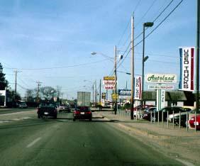
Density and location aside, the pattern of development itself increasingly follows a simplified national model that seems alien to local traditions. Zoning based in the laudable goal of making development safe and predictable has the unintended consequence of reducing every landscape to the lowest common denominator, and favors developers who bring in simple cookie cutter subdivisions with wide, flat roads. In commercial development these same trends towards simplicity and homogenization are driven by engineering standards, as well as trademarked corporate architecture designed to be recognizable from coast to coast. At the same time the economies of scale favored by the market have led to ever larger buildings, culminating in the category-killing, big-box super stores now popping up on the edge of every town in the country.
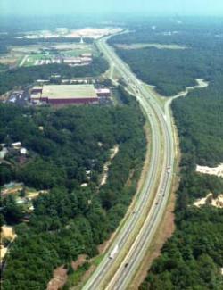
Perhaps the largest factor in all of this is our dependence on the automobile. Driven by an understandable and almost universal individual goal of owning one's own car and home, corporate America and government at all levels have spent the last 50 years building highways and suburbs, and more suburbs and highways _ draining the vitality from city centers and forcing a dependence on the automobile. Today many people can't get to work, shopping, schools, or recreation without cars. An investment of trillions in the interstate highways, together with inexpensive cars and the fuel to power them, supports an increasingly decentralized pattern of development. All of which is fine with most people, as long as there's enough money to repave the highways and buy the gas. Yet in metropolitan regions like Washington, DC, Atlanta, Los Angeles and San Francisco traffic congestion has doubled and tripled commuting times, turning a personal inconvenience into a drag on the economy. And it's not easy to put the genie back in the bottle after development has spread out across the countryside which is why corporations, and their employees, are starting to take a second look at dense traditional cities like Providence, or regions like New York City, where millions of people have access to dependable mass transit systems. The economic advantage of regions that control their dependence on cars and trucks for transport of people and goods will be increasingly evident as energy prices continue to rise and subsidies for road construction and repair dwindle.
Despite these powerful national trends, and sprawl-inducing local zoning, South County remains mostly open and rural, with thousands of acres of undeveloped land and a high quality of life. A few key facts and figures from the Pawcatuck Watershed Partnership's Watershed Report help to set the scene:
- A population of about 60,000 people on 300 square miles, an increase of 20% in the last decade.
- Approximately 65% of the land is still undeveloped, of which 31% is already permanently protected natural habitat.
- 20% open farmland, most of it managed by 70 large-scale farmers.
- 80% covered by forest, including most of the 14% of the watershed that is wetlands.
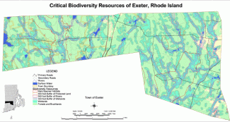
- A mix of northern and southern plant and animal communities on a rich habitat, with 63% of Rhode Island's rare plants and animals.
- Underlying everything, an EPA-designated Sole-Source Aquifer - South County's only existing or potential future water supply.
South County thus represents a unique place at a unique time, a time when residents of the region still enjoy the benefits of its natural and cultural history, which are threatened as never before by development patterns that ignore that history and treat everything as a blank slate. A unique time because South County will never again have the chance to shape growth as much as it can now. And there isn't much time to talk about it: long before every house site and commercial zone is developed the unifying natural and cultural landscapes will be fractured and fragmented by a hundred small projects. What will be left is a region without the rural character that draws people here in the first place and makes for a high quality of life. It will feel much more suburban, with roads lined by commercial strips and subdivisions, and nature restricted to parks and preserves surrounded by houses — not a bad place to live, but dramatically different from what exists today.
The South County Watersheds Technical Planning Assistance Project
The problems of suburban sprawl are not unique to Rhode Island, of course, and planners at the state and local level have been working steadily to apply the lessons learned elsewhere to the local situation. In 1999 this effort crystallized around a project developed by a coalition of groups including the Rhode Island Department of Environmental Management, the Rhode Island Rural Lands Coalition, and the South County Planners. The idea was to prepare a comprehensive review of best possible solutions from around the country and show how they could be applied locally. Under a grant from the US Environmental Protection Agency, this became the South County Watersheds Technical Planning Assistance Project. Under the management of the Sustainable Watersheds Office of Rhode Island DEM, a multi-disciplinary consultant team led by Dodson Associates was hired to do the project. Working with an Advisory Committee of more than sixty town planners, elected officials, and citizens that were selected by the nine South County towns, the consultants developed a suite of "Smart Growth" tools _ including this Design Manual, a set of Model Zoning Ordinances, Strategies to promote Farming and Forestry, a study of Transfer of Development Rights, and a Development Site Assessment Guide. Each of these products was designed to take the best examples from around the country and shape them into tools that would be most effective in South County but could also serve as a model for other rural and suburban communities. Some, like the Design Manual, are primarily educational in nature; others offer specific tools and regulatory language for shaping development _ it is hoped that together, these will help towns on many levels as they work to plan for growth in this unique corner of New England.
The Design Manual Approach
The Design Manual is a record of a process the Advisory Committee went through in order to identify the key issues and potential solutions to problems faced by South County Towns. From a list of about 25 possible sites, eight were chosen to represent a cross section of possible development types, transportation issues, environmental challenges and social contexts. Some of the sites, for instance, are directly off I-95, while others have potential rail access or are constrained by poor road connections. Some of the sites are within or on the edge of existing towns and villages, while others are out in the countryside. Ranging from tens of acres to several thousand, the sites also explore issues at a range of scales, from detailed issues of infill within a streetscape, to large-scale development patterns across a rural district.
Base maps and resource overlays were prepared for each site based on information from Rhode Island Geographic Information System. Aerial photographs of each area were taken to serve as the basis for illustrations. Grouping the sites by theme - residential, commercial, mixed-use, etc. - Dodson Associates led a series of workshops with the Advisory Committee to explore how each site could be developed. First, the group examined how each site would most likely be developed under current zoning regulations and market trends. For residential zones in South County, this usually means subdivision roads and one or two acre house lots. For commercial zones, the conventional development plan most often leads to development of frontage lots along existing highways - the commercial strip. The second scenario explored how it might be possible to fit the same amount of development on a site as allowed under the conventional plan, but in more creative and sustainable way. This often means allowing more of a mix of uses on sites, promoting pedestrian access, and encouraging flexible development standards within an overall master plan. Each of the design scenarios, then, is completely imaginary _ but they are based on careful study of the physical and regulatory constraints that affect actual sites. As a result, many of the issues and problems inherent in developing in South County were identified early on, so that the consultants could look for potential solutions, whether through zoning changes, flexible development standards, planning concepts or detailed design approaches.
To illustrate these complex planning issues, and potential design solutions for each site, birds-eye view drawings were prepared that show both large-scale planning ideas and detailed design of streets, buildings, parking lots, etc. In each case, the first drawing illustrates existing conditions on the site. The second image shows what is likely to happen under current zoning and development trends. A third image illustrates a more creative approach, in many cases based on pedestrian-friendly, mixed-use development. The design manual is built around this set of three images of each site, surrounded by descriptive text and photographs illustrating existing conditions and examples of conventional and creative approaches to development. It is designed primarily as an educational resource, but could also be used as a reference in regulatory review of site planning and design.
The Creative Vision of the Design Manual
Model Land Use Ordinances
As each of the planning and design scenarios were being developed and discussed by the steering committee, the consultant team worked to identify the planning, policy and regulatory changes that are needed to implement the creative plan. In most towns, zoning and other regulations make it impossible to build anything other than the conventional plan, at least by right. A set of alternative Model Zoning Ordinances, prepared by Attorneys Mark Bobrowski and Andy Teitz, was prepared to promote the creative development recommended in the design scenarios: they include elements to help towns more effectively plan for growth, particularly through better design review procedures, fees for design review, and growth rate controls; they also include alternatives to the usual forms of residential clustering and planned commercial districts that have failed towns in the past. The suggested models keep the basic idea of these older approaches, but go a step further, by promoting the idea of several different kinds of flexible and planned district development to be applied depending on the specific context of a project site. For example, the project team noted that the one-size-fits-all cluster zoning common to a number of towns treats all areas of a town alike. While it allows smaller lots and requires preservation of open space, it is a very blunt instrument in promoting better design. So the model ordinances suggest several alternatives customized to specific situations. In rural districts where preservation of large contiguous tracts of farmland, forest, or river corridors is paramount, a Conservation Subdivision Ordinance emphasizes site plans that reflect an understanding of town-wide open space systems. In village locations a different approach, termed Flexible Development, emphasizes the design of streets, houses, and neighborhood structure over open space protection, per se. Similarly, the models provide two different options for mixed-use commercial development in planned development districts, depending on whether the site is in the countryside or close to an existing village or town.
Working Landscape Preservation
The second implementation element was a report outlining strategies to promote Farming and Forestry in South County. This study was prepared by Rick Taintor of Taintor & Associates, and combined regulatory approaches such as a Rural Village Development district, and an ordinance governing farm-based retail sales, with incremental approaches to promoting farm-based service businesses, lowering tax burdens on farmers, and generating local funding support.
Transfer of Development Rights
Another element prepared by Taintor & Associates was a study of the possible application of Transfer of Development Rights (TDR) to South County. TDR , as he describes it, "is a land use regulatory tool under which development rights can be severed from a tract of land and sold in a market transaction. The parcel from which the rights are transferred is then permanently restricted as to future development, and the purchaser of the rights may assign them to a different parcel to gain additional density…Usually, TDR programs designate sending areas from which rights may be transferred, and receiving areas to which the rights may be sent." This creative management tool takes the kind of flexibility that towns often allow to shift house lots around on one parcel, and makes it possible to transfer houses from one parcel to another elsewhere in the town. In theory this makes it possible to preserve sensitive farmland or open space entirely, without having to spend any public funds to buy it .
Site Assessment Guide
The last element prepared by the consultant team was prepared by Lorraine Joubert and Jim Lucht of URI Cooperative Extension. As part of a general study of best management practices for minimizing the effect of development on the environment, the URI-CE team developed a Rapid Site Assessment Guide that towns evaluate the suitability of sites for development. Utilizing the extensive data available from on the Rhode Island Geographic Information System, the Rapid Site Assessment system allows planners, developers and town boards to evaluate possible environmental impacts very early on in the development review process - heading off poor planning decisions before land owners and developers have spent a lot of money on site surveys and engineering.
Planning approaches
As these different creative approaches to design, growth management and regulation were presented by the consultant team, it became clear that little is going to change without the support of town officials and private citizens. Better design or creative regulation won't be adopted as official policy without a shared consensus. The only way to achieve that consensus is through comprehensive planning activities on both the town and regional scale. Planners in most towns, for example, realize that subdivisions often get built in the wrong places — far from services, near sensitive wetlands, on poor soils, etc. Zoning usually requires larger lots in such places, but otherwise developers build the same subdivision roads out in the countryside as in the town center. The answer is to pursue planning at a more detailed scale within neighborhoods and districts within the town, figuring out ahead of time which areas should be protected, and which areas are more suitable for development. This has been done in most towns at the scale of the whole town the problem is the level of detail is rarely enough to show which parcels should be protected, much less delineating areas within parcels.
With the advent of Geographic Information Systems, and particular the data that is available from Rhode Island GIS, it is possible to do this kind of detailed planning for many times less than you could even ten years ago. A companion, called the South County Greenspace Protection Project, is designed to demonstrate how RIGIS data, and the knowledge of local volunteers, can be used to identify the areas and corridors of open space that should be protected within and between towns. A parallel project, known as the South County Economic Development Planning Project, is designed to complement the identification of desirable open space resources with an investigation of appropriate locations and types of economic development across the region. Both these projects represent regional planning at a scale and level of detail that can be truly effective in informing local planning and management decisions.
Improvements in the speed and efficiency of GIS will increasingly allow towns to pursue this kind of detailed physical planning as part of their comprehensive planning efforts. Now, most towns have a land use plan and zoning map which shows the location, allowable uses, and density of development in each neighborhood. Few towns, however, talk about the appearance of the development, size and scale of structures, etc. This creates a lot of uncertainty. Zoning changes meet resistance because people don't know what to expect, there's no agreement ahead of time on anything but goals that are so broad to sometimes be meaningless. But, if you can establish specific, physical planning goals up front, zoning changes become much easier simply a tool to implement an accepted plan. In theory, zoning is meant to implement the land use element of the comprehensive plan, and in most towns there is an explicit connection; the problem is the landuse plan itself is rarely detailed or specific enough.
Conclusions
The Design Manual was, and is, the centerpiece of the project — not because it is the most important, but because it connects the other pieces together like the hub of a wheel. The Model Zoning Ordinances, Strategies to promote Farming and Forestry, and Site Assessment Guidance all grew out of the detailed local analysis made possible through the design manual approach. While as a product it focuses on better site planning and design, the Manual shows that these can be achieved only through a more flexible approach to regulation, coupled with more detailed planning at the scale of the neighborhood, town, and region.
The scenarios show that there are choices to be made. First, if towns do nothing to change their approach to planning or regulation of development, there is a predictable outcome — often one which is not supported by the local Comprehensive Plan, but hidden within the zoning map and the text of the regulations. If they simply do nothing, most towns will change considerably as a result of the conventional scenario, and rarely for the better. The Creative Scenario shows that an alternative to "business as usual" exists, that development can continue, but need not obliterate the unique character of our historic towns and villages. Indeed, with some foresight the development process itself can be harnessed to accomplish the twin objectives of economic development, open space preservation, and environmental protection.
Second, the Design Manual shows that while many of the principles of smart growth can be applied anywhere, their successful application depends on a design process that respects and builds upon the characteristics and context of each unique site. One of the lessons we have learned is there are no blank slates, that if we apply "sustainable development" principles mechanically, as if every site is the same, the result on the regional scale will be little better than the conventional development approach.
Another thing to keep in mind is that the most wonderfully designed, context-sensitive development can still fail if not guided by an integrated program of town and regional planning. A number of award winning "New Urbanist" projects have been completed, for example, that are lovely within themselves, but on the regional scale represent just another form of sprawl. Especially in rural areas, there is a limit to the carrying capacity of the land, roads, water supplies, sewerage, schools, emergency services, etc. Shifting development around a site or even a whole town can make a much better design, but it can still mean hundreds or thousand of new residents. Dealing with these larger issues is more of a political question, perhaps, but by using the "scenario planning" approach at least the alternatives become clearer. Thus, one of the conventions used in the scenarios is to show at least the same amount of development in the creative scheme as can be built under the conventional approach. In most cases this illustrates that well-planned development takes up less space and uses land more efficiently leaving more land to preserve for parks, trails, and wildlife habitat. In other cases, however, it is clear that the allowable density or number of new units is simply too high for the neighborhood.
With these caveats in mind, then, what makes better design? Is it just a matter of individual taste, or are there fundamental principles that tie the surface appearance of a building or street to its practical value and long-term environmental sustainability? In general, we start with the premise that, in this world of increasingly standardized everything, one of the few things that makes our lives special is the unique natural and cultural environment in which we live. Good design is that which allows growth and change to occur in a way that respects this existing context, that works with it, rather than destroying it. Good design must also be more sustainable on a practical level, that is, requiring fewer resources to build and maintain and requiring a minimum amount of energy for its use. Finally, good design must tie neighborhoods and towns together with a common thread of attractive architecture and site design that builds on local traditions.
In the following chapter we compare historic development patterns and design traditions to today's common practices, and suggest some alternatives that meet the demands of the modern marketplace with designs that fit in with South County's traditional character. Several overarching design principles are introduced that are common to many of the design scenarios, including the concepts of mixed-use development, pedestrian-friendly design, and livable neighborhoods. Finally, chapter three presents the scenarios themselves, beginning with an introduction that describes the sites in comparison to the type of South County site each is meant to represent.