Chapter 3 -- The Planning and Design Scenarios
For the last few decades, people all over the country have been working on solutions to the problem of suburban sprawl. This begins with better design, often combined with planning that promotes protection of open space and revitalization of traditional town centers. The planning and design journals are full of ideas for "neotraditional town planning," "new urbanism," "sustainable design," "smart growth," etc. This manual is designed to make these ideas more tangible by showing how they could be applied right here in South County, solving local problems with architectural and site planning approaches that are based on local traditions. To do this, the South County Design Manual is built around eight design scenarios prepared for representative sites around South County. Each of these hypothetical case studies take an actual site and shows how it would most likely be developed in today's market, following current zoning and other regulations. A more creative development alternative for each site was drawn up to demonstrate how the same or greater amount of development could be accommodated on each site while preserving important resources. It is important to remember that these future development alternatives represent realistic, but completely imaginary possibilities: no public or private entities are proposing to build them.
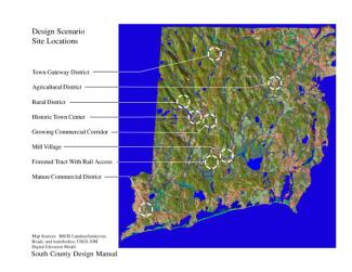
The eight scenario sites were selected with the help of the project steering committee, which nominated for study many areas identified in local comprehensive plans as potential development sites. A wide range of landscape types and planning situations was developed so that a site in one town might serve to demonstrate similar issues and potential solutions that can be applied in many others. Transportation connections play a large role, as they do in most real-life development decisions, so a number of sites explore the influence of the Interstate 95 corridor and well as the recently-upgraded Amtrak line. The sites include "town gateways," such as the area of West Greenwich adjacent to Exit 5 and the agricultural district on the Border of Exeter and North Kingstown where Route 2 meets102. Some of the sites represent landscapes in transition, such as the so-called United Nuclear site in Charlestown, or the vacant lots and gravel pits along Rt. 138 in Richmond. Other areas, like the village of Shannock, are gradually evolving from self-sufficient mill villages to residential enclaves. Likewise, the entrance to Westerly on Route One represents an area struggling to keep up with changes in commercial markets.
The Design Manual is set up so that each of the eight scenarios serves as a free-standing example of development alternatives for a particular situation. Readers are encouraged to pick and choose from those scenarios that match local situations. Each full-page illustration of existing, conventional, and creative development is accompanied by a page with photographs of the site in question, or actual examples of the type of development illustrated in the drawings. Details of the creative development illustration are enlarged and surrounded by written design recommendations. A final page describes for each scenario the implementation techniques that might be employed to achieve the desired ends. These include planning ideas, like detailed masterplans for Main Streets or neighborhoods, as well as zoning or other regulatory techniques. Examples from projects around the country complete the picture.
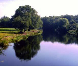
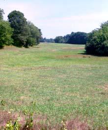
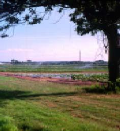
The Rural District scenario depicts a rich cultural landscape marked by a mixture of rural roads, small farms and historic villages. Within an area of only a few square miles lies an extraordinary diversity of landscapes, from small mill villages stitched together by the state highway that follows the valley, to the meadows and woodlots that link an agricultural corridor along the adjacent ridgeline. Current zoning treats this diverse landscape as a blank slate, parceling both village and countryside into the same 2-acre house lots. The recommended alternative takes the same amount of development and rearranges it to protect sensitive natural and cultural resources, while revitalizing existing centers. In agricultural landscapes, this might mean clustering development away from streams and off farm fields, creating a new neighborhood of smaller lots in one area of a parcel. For mill villages, it means allowing the flexibility to infill on smaller lots within the village and providing for some careful expansion while maintaining a definite edge between village and countryside.
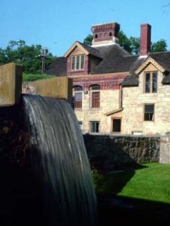
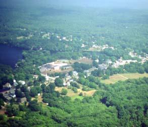
Scenarios for an Historic Town Center explore ways to accommodate growth and change in a place where little physical or visual change is desired. As in many villages, the ponds and river that powered the mills, and a dense development pattern restrict further growth. As a result, there's little room for additional development without taking away existing structures. These include wonderful artifacts like the old mills and their dams and sluiceways, historic shops and storefronts along Main Street, and a cross section of architecture from the last two hundred years. This wide variety of civic, commercial, residential and industrial uses is brought together by a walkable, human-scaled streetscape. The trend, however, is toward larger scale of development favoring automobile-dependent commercial uses. Existing lots too small for such uses are frequently consolidated, the existing structures demolished and replaced by gas stations and convenience stores. Chain architecture and cookie-cutter corporate site plans replace historic structures. New buildings are set back from the street with parking in front, making the street less comfortable for pedestrians and ruining the streetscape. The creative alternative presents a compromise, where uses can continue to change and evolve, but only if they respect existing structures and the character of the street.
For a Large Forested tract with Rail Access, the planning alternatives explore the possibilities of fairly large transit-oriented development in a undeveloped part of town. The conventional development scheme depicts what many people see as a boon to a small town: a large golf course with condominiums, a landscaped office park surrounded by trees and grass, with a cute town center around a railroad station. Despite a nod to village design, however, such a scheme remains totally dependent on the automobile, with residential, commercial, and office uses separated into different zones and strung out across the site. A more traditional town-style plan, by contrast, places all uses within walking distance of the village center. This is made possible by higher densities, with mixed uses not only within neighborhoods, but within structures, where the ground floor might have shops, with offices and apartments in the upper stories. Attractive streets, landscaped parks and squares, and a large greenbelt surrounding the whole town provide a contrast to the compact downtown. Outlying neighborhoods have larger lots and single-family homes, many of which retain the open space vistas that make the conventional golf-course development so marketable.
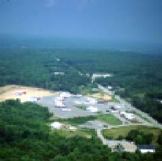
The Town Gateway District represents a scenario common to many South County towns, a number of which have zoned outlying areas adjacent to the highway for large-scale commercial or industrial uses. While often the only land available for extensive new development, these areas also are the principal gateways into the town. Poorly-planned development can extend sprawling subdivisions and commercial strips and blight one's first impression of the community. Creative development takes this growth pressure and directs it to create a new village center with a mix of commercial, office, residential, and civic uses within a compact, walkable center. An important part of this scheme is how the public spaces created by well-planned streetscapes, central green spaces and carefully-located buildings serve to unite a diverse collection of uses and architecture. Thus a large commercial building can coexist with a smaller residential structure without looking out of place, for both relate to a larger unifying concept. This makes for a community that can growth and change organically over time, accommodating many different uses, while retaining the livability and attractiveness that will attract and retain residents and businesses over the long term.
Older commercial districts have a unique set of problems. In the Mature Commercial District, ever larger supermarkets, stripmalls, and office buildings are gradually changing a residential neighborhood on the edge of a small city into a commercial strip. The conventional impulse is to rationalize these new uses within a well-ordered plan built around the highway corridor, with existing residences carefully separated from commercial uses and buffered with vegetation. A more creative solution allows new uses to come in, but makes them subservient to the scale and functioning of the existing residential neighborhood. Thus, rather than allowing the district to be divided into incompatible zones, the creative scheme uses the new investment to knit the neighborhood together into a coherent whole. The whole neighborhood is then more like the traditional neighborhoods of the city, creating a sense of identity and an attractive gateway to the community.
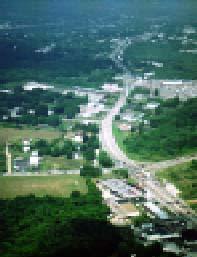
Lacking other areas for business development, towns often zone state highways for office and commercial use. The Growing Commercial Corridor scenario shows how these uses tend to spread out across the available lots, with little coordination between developments, much less adherence to some over-arching masterplan. Towns typically focus on improving the appearance of the development through controls on architecture and landscaping, without addressing the underlying sprawl pattern of development. The creative alternative depicts how the investment in new roads and buildings can be redirected to produce something that looks and functions more like part of a real town, making a better place to do business while improving the appearance of the neighborhood.
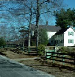
The Agricultural District scenario explores the challenges of preserving agricultural areas in the face of pressure to develop what is, for many towns, the cheapest and most buildable land. Often cherished by residents for its scenic vistas and nostalgic associations, farmland at the same time is often the sole legacy of the farmers themselves. Efforts by towns to reduce density to three or four acres per unit can result, as in this case, in forcing landowners into development of large-lot residential subdivisions that consume more land for less profit. The recommended alternative allows a much broader list of uses to come in, but restricts them to a fraction of the total site. Through clustering, the development that could spread across the entire area is channeled into a compact, pedestrian-friendly center; by allowing a conversion of that development from residential to commercial uses, moreover, higher profits are generated which pay to preserve more farmland. The resulting village, surrounded by permanently-protected open space, is a more attractive place to live and work, while generating higher tax revenues and fewer school children than the conventional plan.
Like the historic town center, the Mill Village scenario explores alternatives for growth and development in a place with a rich legacy of narrow lanes, historic buildings, and surrounding open spaces still free from development. In the smaller mill villages of South County much of the industry is long gone, and they are in transition to something else. This scenario compares one kind of future, where the village becomes primarily a bedroom community surrounded by residential subdivisions, with an alternative that says the village can and should be revitalized as an active mixture of homes, businesses, shops, and civic uses. With careful planning and design, and a concentration of investment at the core, the historic center becomes the seed crystal for a modest expansion of the whole village. Development that would otherwise spread up into the surrounding hills and down the highway strip is gathered in and made part of a walkable neighborhood. The likelihood that this will continue as a real community, where people know each other and participate in local life, is much higher in this kind of traditional setting than in the sort of faceless suburban environment that is in fact the easiest thing to build under current regulations.
Each of the planning and design scenarios, then, is something of a dream. While they have been drawn up for actual sites, no one is building the creative plan - and in fact the conventional alternative is much more likely to happen. Questions of water supply, access, parking, wastewater treatment, ownership, and financing are real roadblocks - but not insurmountable ones. Our goal is to offer an alternative vision for the future of South County _ it will take new approaches to planning, design, and development to make that vision a reality.
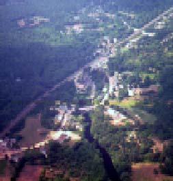
Design Scenario Site Locations