Narragansett Bay Menhaden Monitoring Program
Background
The Narragansett Bay Atlantic Menhaden monitoring program began in 2008. The purpose of the survey is to monitor the biomass and distribution of Atlantic menhaden within Narragansett Bay. The data collected is used in conjunction with sentinel fishery observations (floating fish trap data), fishery landings information, computer modeling, and biological sampling information to open, keep track of, and close the fisheries on menhaden as conditions dictate.
Survey Design
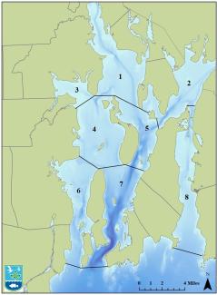
The survey encompasses eight areas within the Narragansett Bay menhaden management area. This area includes the east and west passages of Narragansett Bay, Mt. Hope Bay, and the Sakonnet River, and is bordered on the south by a line from Bonnet Point to Beavertail Point to Castle Hill Light. The southern boundary further extends from Land's End to Sachuest Point and then to Sakonnet Light.
Survey Gear
The survey is conducted by a licensed pilot on his/her aircraft that is capable of completing the survey.
Sampling Methods
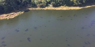
A menhaden spotter pilot is contracted annually to survey the eight areas encompassing the Narragansett Bay menhaden management area. the flight path consists of east to west transects moving in a northerly or southerly direction in each survey area with all turns occurring over land. Data collected for each area consists of the total number of schools and total biomass (lbs) of menhaden.
Sampling Frequency
A total of 40 flights are conducted twice per week, from May 1 through November 30 annually.
Sampling Locations:
For more information about the survey please contact Nicole Lengyel Costa