Offshore Wind
RIDEM Involvement in Offshore Wind Development
The RIDEM is supportive of offshore wind energy development in an effort to mitigate the impacts of climate change and reduce greenhouse gas emissions. Our agency is committed to ensuring that the local and regional environmental and socioeconomic impacts of offshore wind development are minimized. The DEM contributes to the successful development of offshore wind farms by:
- Providing the best available science and data to understand potential impacts of development on both marine resources and the fisheries the depend on them
- Working directly with wind developers to make project siting and layout recommendations to minimize fishing and environmental impact to RI resources
- Reviewing and analyzing raw trawl and ventless lobster survey data collected as part of a Before-After-Control-Impact assessment of the Block Island Wind Farm to better understand potential impacts of offshore wind development on local species and habitats
- These data were collected by Deepwater Wind contractors per the requirements of an RIDEM Water Quality Certificate (WQC# 12-037).
- Deepwater Wind has provided funds to the State of Rhode Island to allow RIDEM to independently analyze these data.
- Reviewing all submitted materials from Deepwater Wind and National Grid to ensure permit compliance (i.e., EMF surveys, hardbottom habitat monitoring, cable burial surveys)
- Organizing Rhode Island Marine Fisheries Council meetings with developers to create added opportunities for public input
- Working as a cooperating agency to the Bureau of Ocean Energy Management (BOEM) during the National Environmental Policy Act (NEPA) permitting process
- This entails reviewing and providing constructive input on the Draft Environmental Impact Statement and the Final Environmental Impact Statement.
- Serving on both the Rhode Island Intergovernmental Renewable Energy Task Force and engaging on the New York Intergovernmental Renewable Energy Task Force under BOEM.
- Contributing directly to the creation of a regional collaborative to study the impacts of offshore wind development on marine habitats, fish, invertebrates, and the fishing industries that rely upon them.
RIDEM Wind Research Priorities (November 2023)
Vessel Monitoring System (VMS) Analysis
- Please note that there are still limitations to this approach. Not all fisheries are covered by VMS; for example, there are no VMS or VTR requirements for the lobster or Jonah Crab fisheries and therefore, we cannot estimate the economic value of these fisheries using this approach. Additionally, VMS is relatively new technology, there is not 100% coverage for all fisheries, and those with full coverage now may not have had full coverage until recently (e.g squid did not require VMS until 2014). Consequently, earlier years should be interpreted cautiously and with a strong understanding of each of the datasets utilized.
- Spatiotemporal and Economic Analysis of Vessel Monitoring System Data within Wind Energy Areas in the Greater North Atlantic (including Addendum I)
- Spatiotemporal and Economic Analysis of Vessel Monitoring System Data within Wind Energy Areas in the New York Bight Call Areas
- Rhode Island Fishing Value in the Vineyard Wind Construction and Operations Plan Area
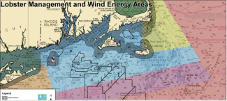
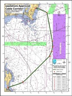
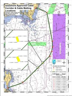
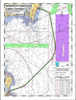
Maps
Comment Letters
- Comments on NY Call Areas
- Comments on Proposed Sale Notice of NY Wind Energy Area
- Comments on NYSERDA Area for Consideration
- Letter to BOEM Re: Development of the NY Lease Area
- Comments on NY WEA EA
- Comments on Vineyard Wind DEIS
- DEM Revolution Wind Advisory Opinion to the Public Utilities Commission
- Comments on Notice of Intent to Prepare an EIS for the South Fork Wind Farm
- Comments on Vineyard Wind SEIS
- Comments on the Mayflower Wind NOI to prepare an EIS
- Comments on the Revolution Wind Construction and Operations Plan
- Comments on NOAA Fisheries and BOEM Federal Survey Mitigation Implementation Strategy
- Comments on the Central Atlantic Call Areas
- Comments on the South Fork Wind Farm DEIS
- Comments on the SouthCoast Wind DEIS
- Comments on the Revolution Wind DEIS
- Comments on Sunrise Wind DEIS
The federal Outer Continental Shelf Permitting Process (used by BOEM in leasing wind energy areas)
Stage 1: Planning and Analysis
- Stakeholder Engagement and Intergovernmental Renewable Energy Task Force Coordination
- Announce Area Identification (WEA)
- Conduct Environmental Assessment (site characterization under National Environmental Policy Act
Stage 2: Leasing
- Continue Stakeholder Engagement through Task Forces
- Issues leases (noncompetitive) or hold lease sales (competitive)
Stage 3: Site Assessment
- Lessee conducts site characterization
- Lessee submits and Site Assessment Plan (SAP)
- BOEM reviews SAP form and environmental and technical standpoints
- If approved, lessee assesses site, usually with meteorological tower(s) and/or buoy(s)
Stage 4: Commercial Development
- Lessee may conduct additional site characterization
- Lessee submits a Construction and Operations Plan (COP) to BOEM for review and approve
- BOEM prepared an Environmental Impact Statement (required under the National Environmental Policy Act
- Approved project receives a 25-year lease term and builds
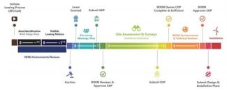
Image courtesy of BOEM
- Click to sign up for email updates from BOEM (e.g. public comment periods opening and public meeting notifications).
- Information on BOEM Leasing Process
- BOEM Activities in Rhode Island
- BOEM Activities in Massachusetts which may affect RI fishing and marine resources
- BOEM Activities in New York which may affect RI fishing and marine resources
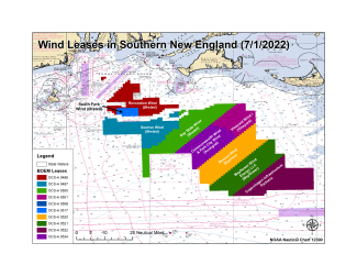
| Project | Company | MW Capacity | Mariners Website | Lease Area | Region |
|---|---|---|---|---|---|
| Block Island Wind Farm | Deepwater Wind/Ørsted | 30 MW to RI | Mariners Website | NA | Rhode Island |
| Revolution Wind | Ørsted and Eversource | 704 MW (400 to RI, 304 to CT) | Mariners Website | OCS-A 0486 | Southern New England |
| South Fork Wind Farm | Ørsted and Eversource | 132 MW to NY (Long Island) | Mariners Website | OCS-A 0517 | Southern New England |
| Sunrise Wind | Ørsted and Eversource | 924 MW to NY | Mariners Website | OCS-A 0487 | Southern New England |
| Bay State Wind | Ørsted and Eversource | Up to 2,000 MW | Mariners Website | OCS-A 0500 | Southern New England |
| Vineyard Wind I | Vineyard Wind 1, LLC (Copenhagen Investment Partners and Avangrid Renewables, LLC) | 800 MW to MA | Mariners Website | OCS-A 0501 | Southern New England |
| Commonweath Wind | Avangrid Renewables, LLC | 1,232 MW to MA | Mariners Website | OCS-A 0534 | Southern New England |
| Park City Wind | Avangrid Renewables, LLC | 804 MW to CT | Mariners Website | OCS-A 0534 | Southern New England |
| Beacon Wind | Equinor and BP | 1,230 MW to NY | Mariners Website | OCS-A 0520 | Southern New England |
| SouthCoast Wind | Shell and Ocean Winds | 1,200 MW to MA (up to 2,400 MW) | Mariners Website | OCS-A 0521 | Southern New England |
| TBD | Vineyard Wind (Copenhagen Investment Partners) | Up to 2,500 MW | NA | OCS-A 0522 | Southern New England |
| Empire Wind 1 & 2 | Equinor and BP | 2,100 MW to NY | Mariners Website | OCS-A 0512 | NY/NJ Bight |
- Mid-Atlantic Fishery Management Council and New England Fishery Management Council Page on Wind in the Northeast
- BOEM Page on Offshore Wind and Fisheries
- Regional Ocean Data Portals
- The Mid-Atlantic and Northeast Ocean data portals are online public resources that consolidate spatial data for marine spatial planning. Layers include fishing areas (VMS and VTR), shipping lanes, areas of fisheries habitat, wind development areas, and many more.
- MARCO - Portal Mid-Atlantic Ocean Data Portal
- NROC - Portal Northeast Ocean Data Portal
- National Academies of Sciences, Engineer, and Medicine Workshop on Atlantic offshore Renewable Energy Development and Fisheries Proceedings
- Development of Mitigation Measures to Address Potential Use Conflicts between Commercial Wind Energy Lessees/Grantees and Commercial Fishermen on the Atlantic Outer Continental Shelf
For more information please contact Julia Livermore